Explore a collection of Israel maps, including a wide variety of physical, political, administrative, and relief maps, detailed satellite images, blank maps, and maps showing Israel’s place in the world. You’ll also find maps of regions, topography, cities, roads, driving directions, and an atlas for even more detail.
Israel Political Map
 Israel political map with capital Jerusalem, national borders, important cities, rivers and lakes. English labeling and scaling.
Israel Satellite Map
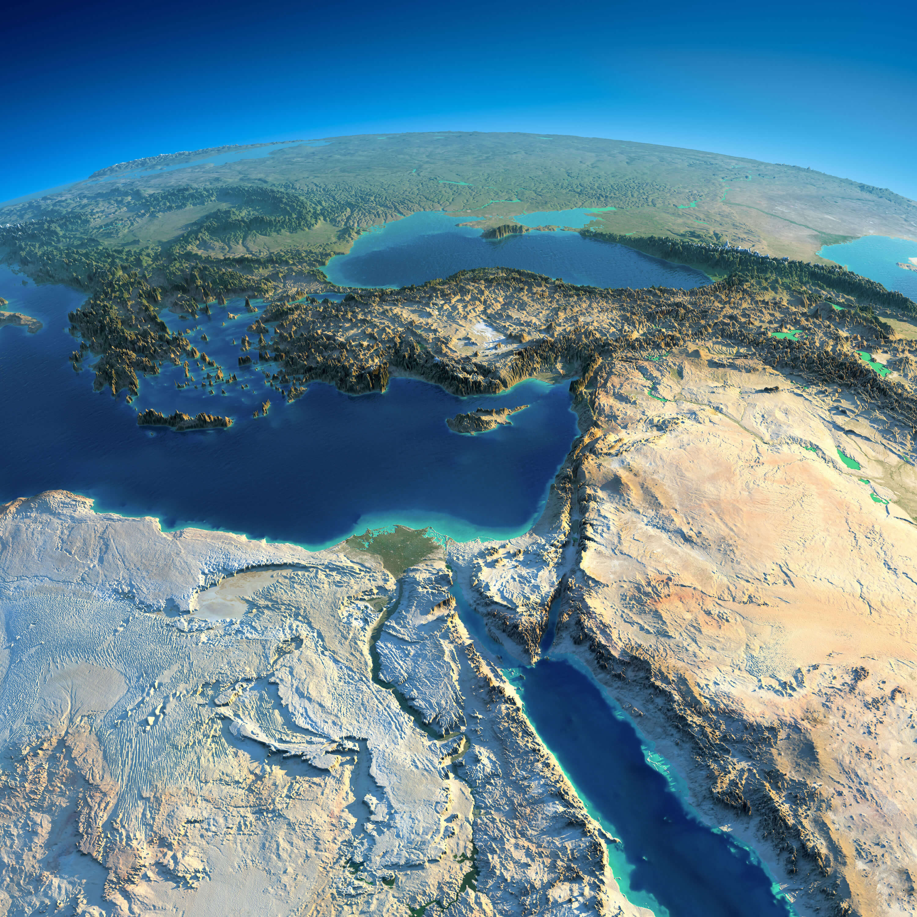 Highly detailed planet Earth in the morning. Exaggerated precise relief lit morning sun. Africa and Middle East.
Political Map of Israel
Israel Palestine Unfolded Map
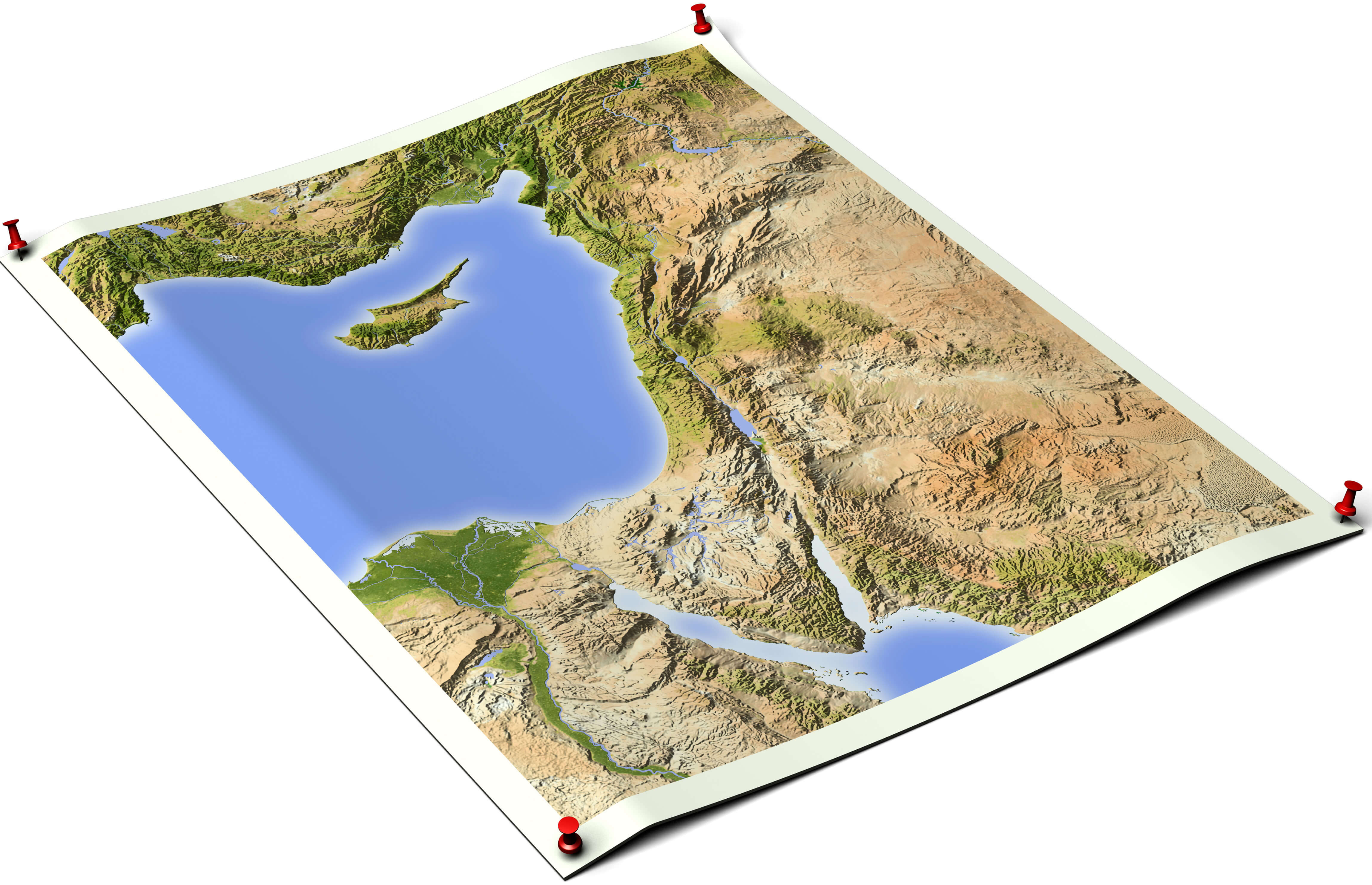
Palestine on an unfolded map sheet with thumbtacks. Map colored according to vegetation. Includes clip path for the background.
Israel Eastern Mediterranean Political Map
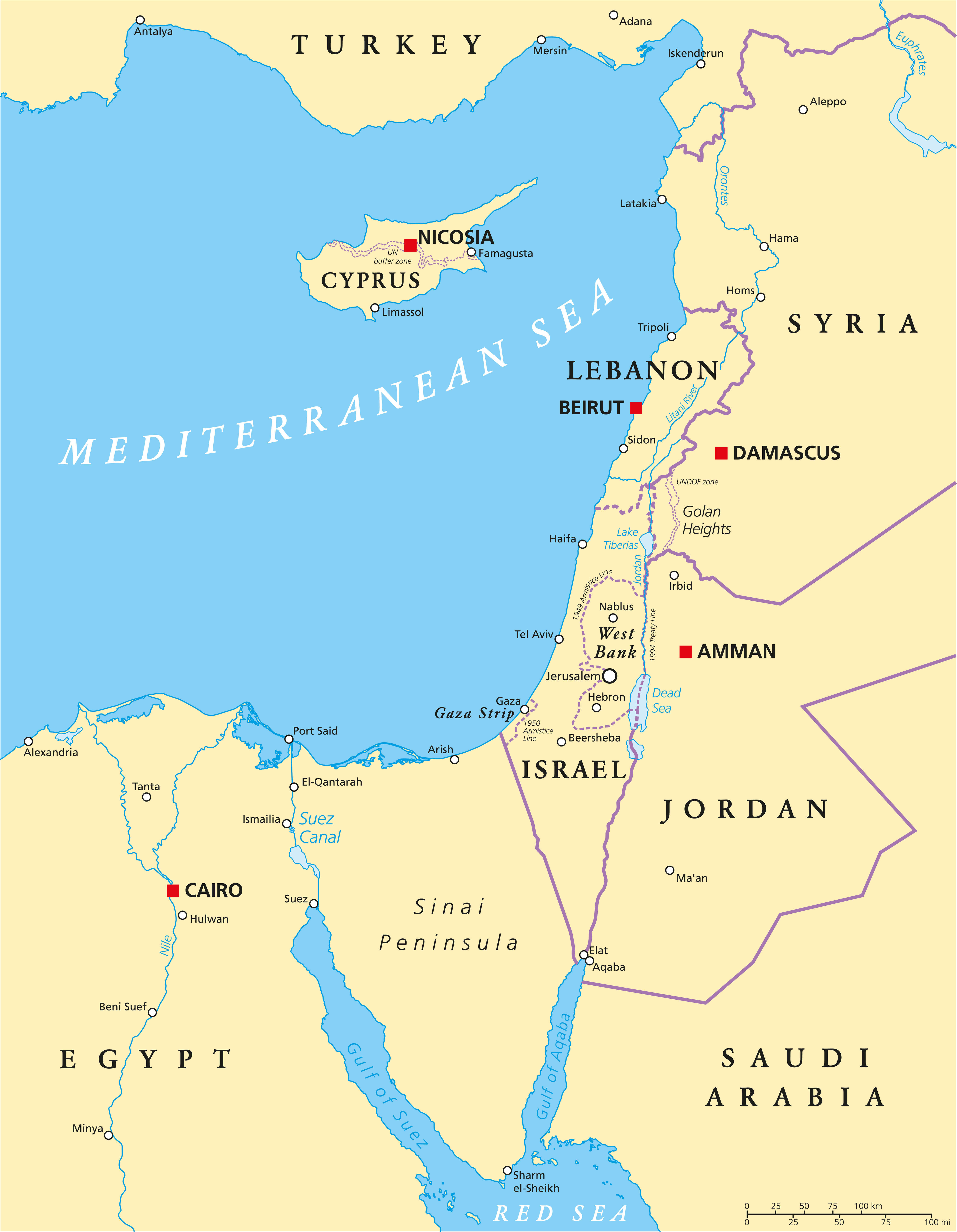 Eastern Mediterranean Political Map with capitals national borders, important cities, rivers, and lakes. English labeling and scaling.
Israel Physical Map

Detailed Israel Physical Map
High-detailed Israel physical map.
High Detailed Israel Road Map
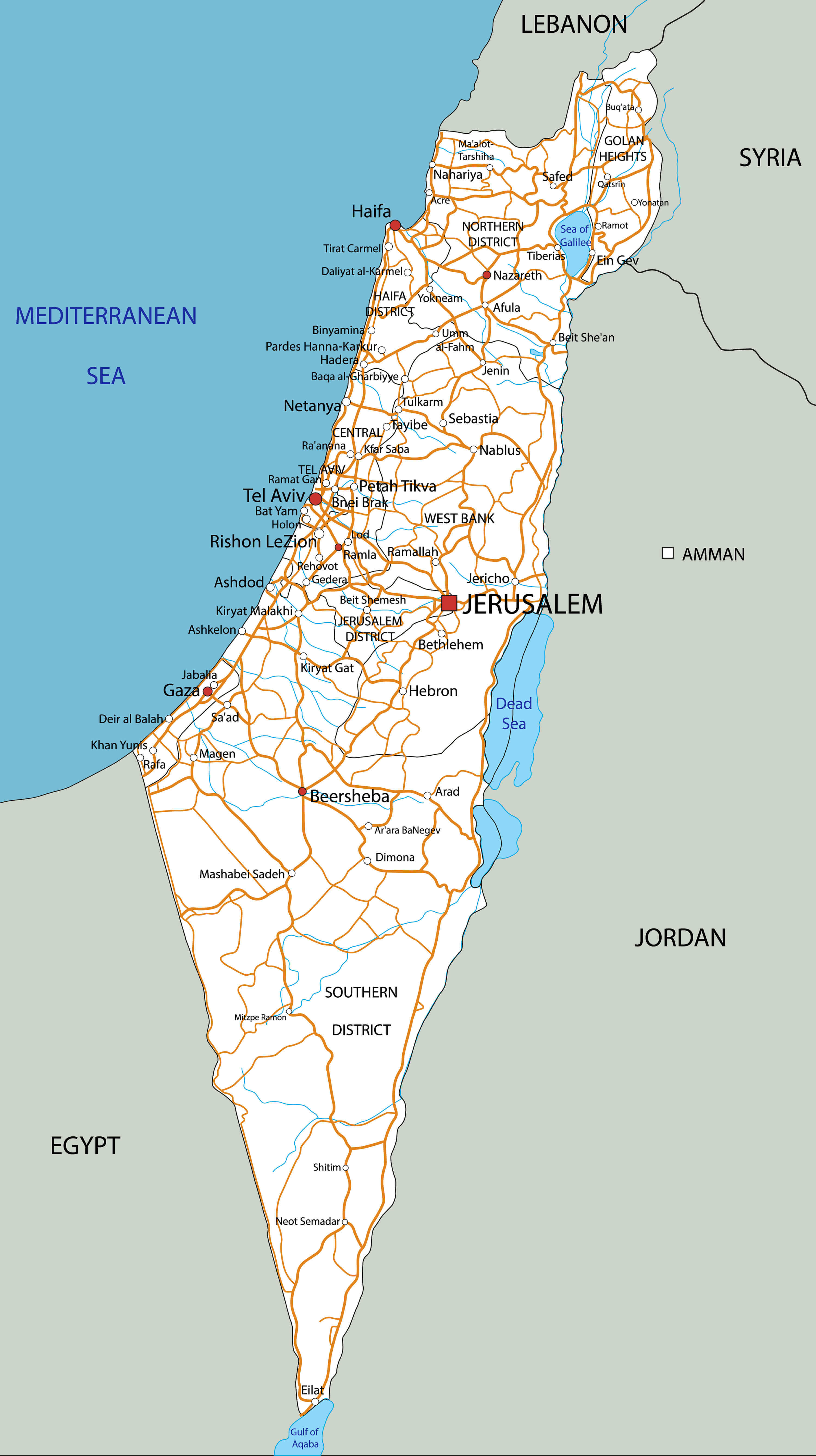
This detailed road map of Israel highlights the country’s primary and secondary highways, along with its cities and important landmarks. Major roads such as those connecting Tel Aviv, Jerusalem, Haifa, and Eilat are clearly depicted, showing Israel’s extensive road network. The map also includes nearby regions and neighboring countries such as Lebanon, Syria, Jordan, and Egypt, providing a comprehensive overview of Israel’s location in the Middle East. Cities like Gaza and the West Bank are also marked, illustrating the complex geography and road infrastructure.
Israel Country Map colored by national flag
Israel – Hezbollah Fighting Map in Southern Lebanon
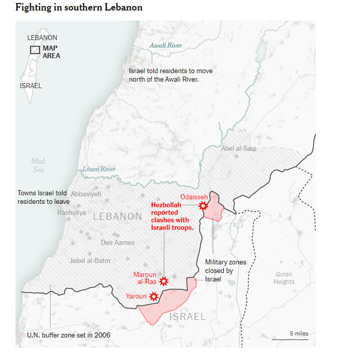
This map shows the ongoing clashes between Israeli forces and Hezbollah in southern Lebanon. Key hotspots such as Odaisseh, Maroun al-Ras, and Yaroun are highlighted, where Hezbollah has reported confrontations with Israeli troops. Israel has closed military zones along its northern border and urged residents of southern Lebanon to move north of the Awali River, beyond the UN buffer zone established in 2006, to avoid conflict.
Israel Info Map
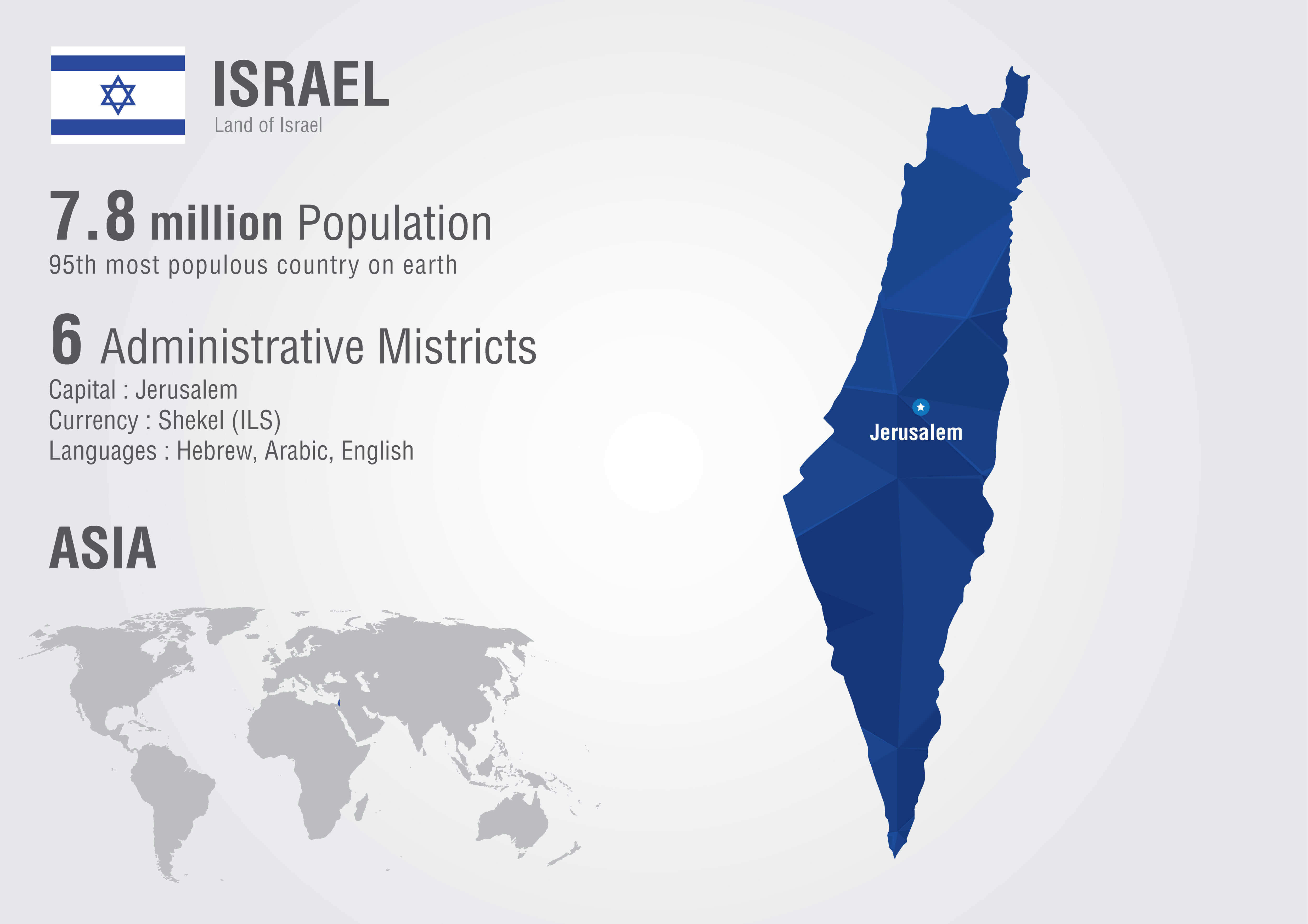 This map provides an overview of Israel, highlighting key facts such as its population of 7.8 million, its six administrative districts, and its capital, Jerusalem. The country’s official currency is the shekel (ILS), and the primary languages spoken are Hebrew, Arabic, and English. Located in Asia, Israel is the 95th most populous country in the world.
Israel Map with Flag
The map of Israel, displayed with its national flag in the corner, highlights key geographic and political features of the country. Jerusalem is prominently marked as the capital, while other major cities like Tel Aviv, Haifa, and Beersheba are also shown. The map outlines Israel’s borders with neighboring countries, including Lebanon, Syria, Jordan, and Egypt, and shows significant areas such as the West Bank, Gaza Strip, and Golan Heights. The Mediterranean Sea forms the western coastline, while the Gulf of Aqaba lies at Israel’s southern tip.
Israel Map with Middle East Conflicts
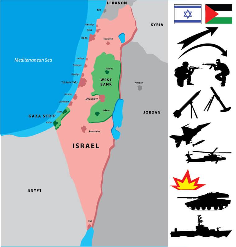
The map depicts Israel’s central role in the ongoing Middle East conflicts. It highlights Israel’s territorial boundaries, including the Gaza Strip and West Bank, areas frequently at the heart of disputes between Israel and Palestinian groups. The map also shows neighboring countries like Lebanon, Syria, and Jordan, indicating their proximity and relevance to regional tensions. The symbols on the map illustrate various military actions, including airstrikes, rocket fire, and ground combat, emphasizing the intensity and complexity of the conflict in this volatile region.
Israel National Map
The Israel National Map showcases the country’s geographic layout, highlighting major cities like Jerusalem, Tel Aviv, Haifa, and Beersheba. Israel is located along the eastern Mediterranean, bordered by Lebanon to the north, Syria to the northeast, Jordan to the east, and Egypt to the southwest. The map also emphasizes key regions such as the West Bank and Gaza Strip, which play significant roles in the ongoing geopolitical context. The map serves as an essential tool for understanding Israel’s administrative divisions, major cities, and its place in the Middle East.
Israel Regions Map with- West Bank Gaza Strip
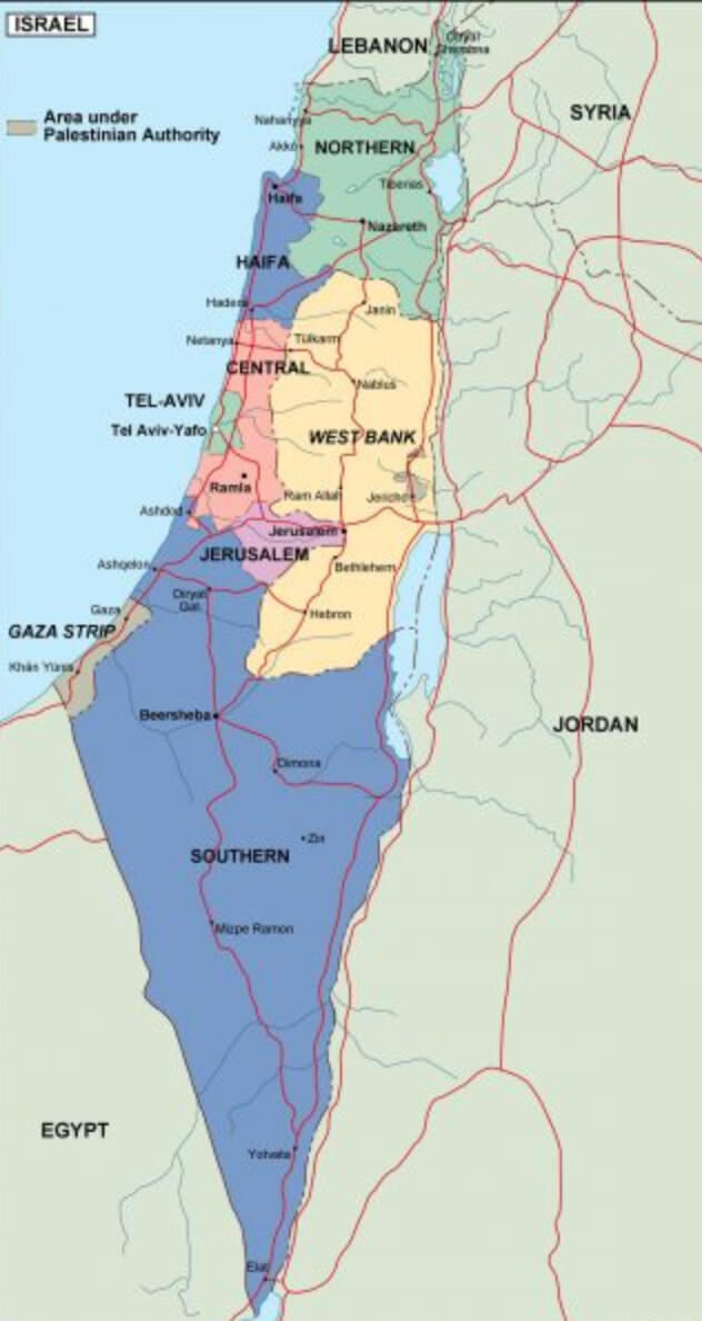
This map shows the regions of Israel, including areas under the Palestinian Authority, such as the West Bank and Gaza Strip. The country is divided into several key regions, including the northern, Haifa, central, Tel Aviv, Jerusalem, and southern districts. The West Bank is highlighted as a separate area to reflect its political and territorial distinction, while the Gaza Strip is shown along the Mediterranean coast in the southwest.
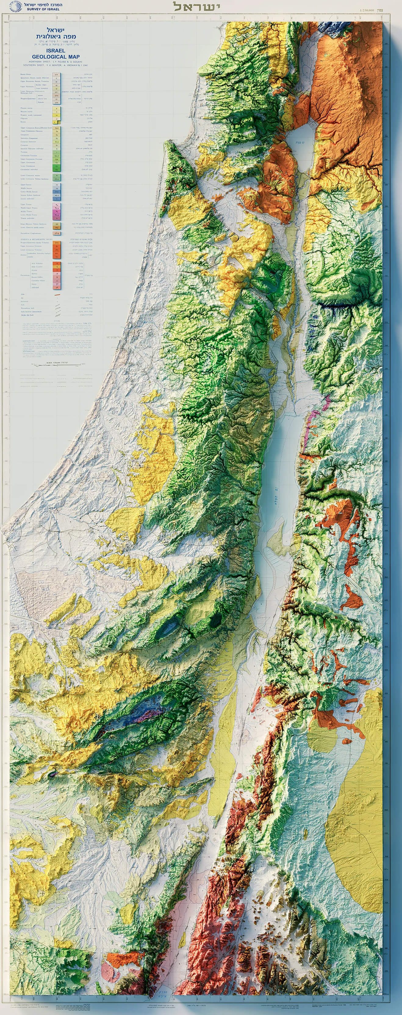
Israel Geological Map
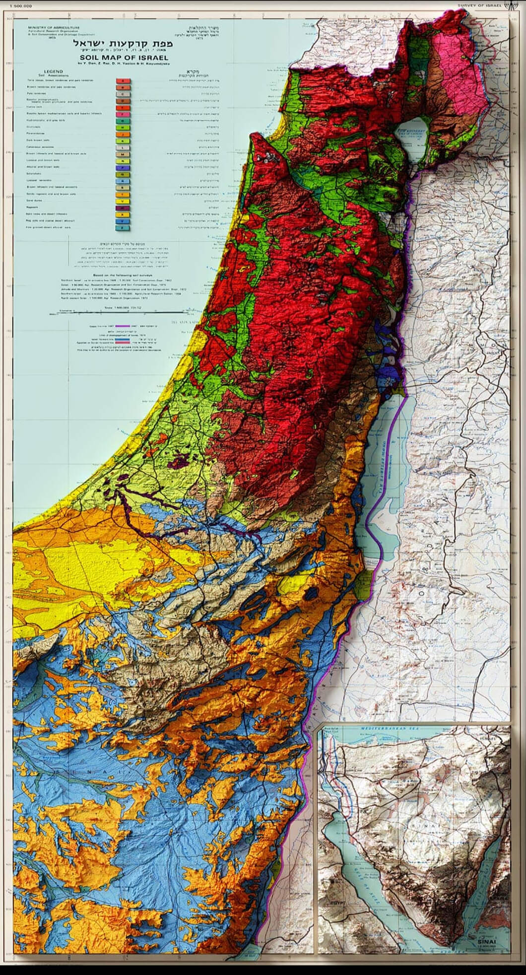
This geological map of Israel displays the diverse soil types and topographical features across the country, showcasing variations in soil composition that range from fertile regions in the north to more arid zones in the south. The color-coded sections represent different geological layers, helping to illustrate the natural resources and landforms of the area.
Israel UN Map Palestine Plan
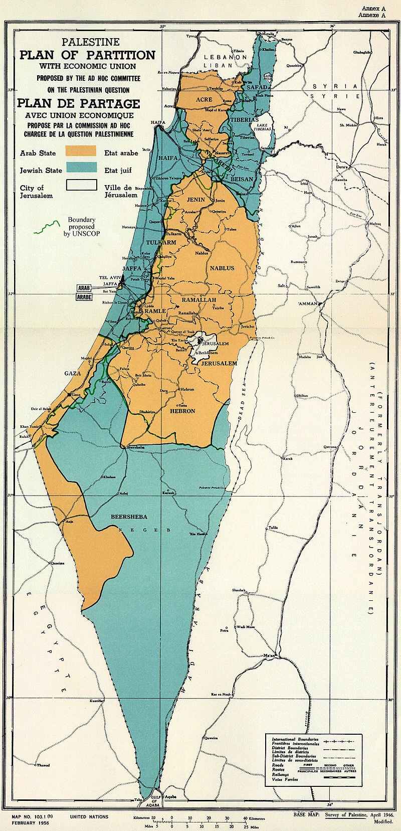
This map shows the regions of Israel, including areas under the Palestinian Authority, such as the West Bank and Gaza Strip. The country is divided into several key regions, including the northern, Haifa, central, Tel Aviv, Jerusalem, and southern districts. The West Bank is highlighted as a separate area to reflect its political and territorial distinction, while the Gaza Strip is shown along the Mediterranean coast in the southwest.
Israel Six Day War Map in 1982
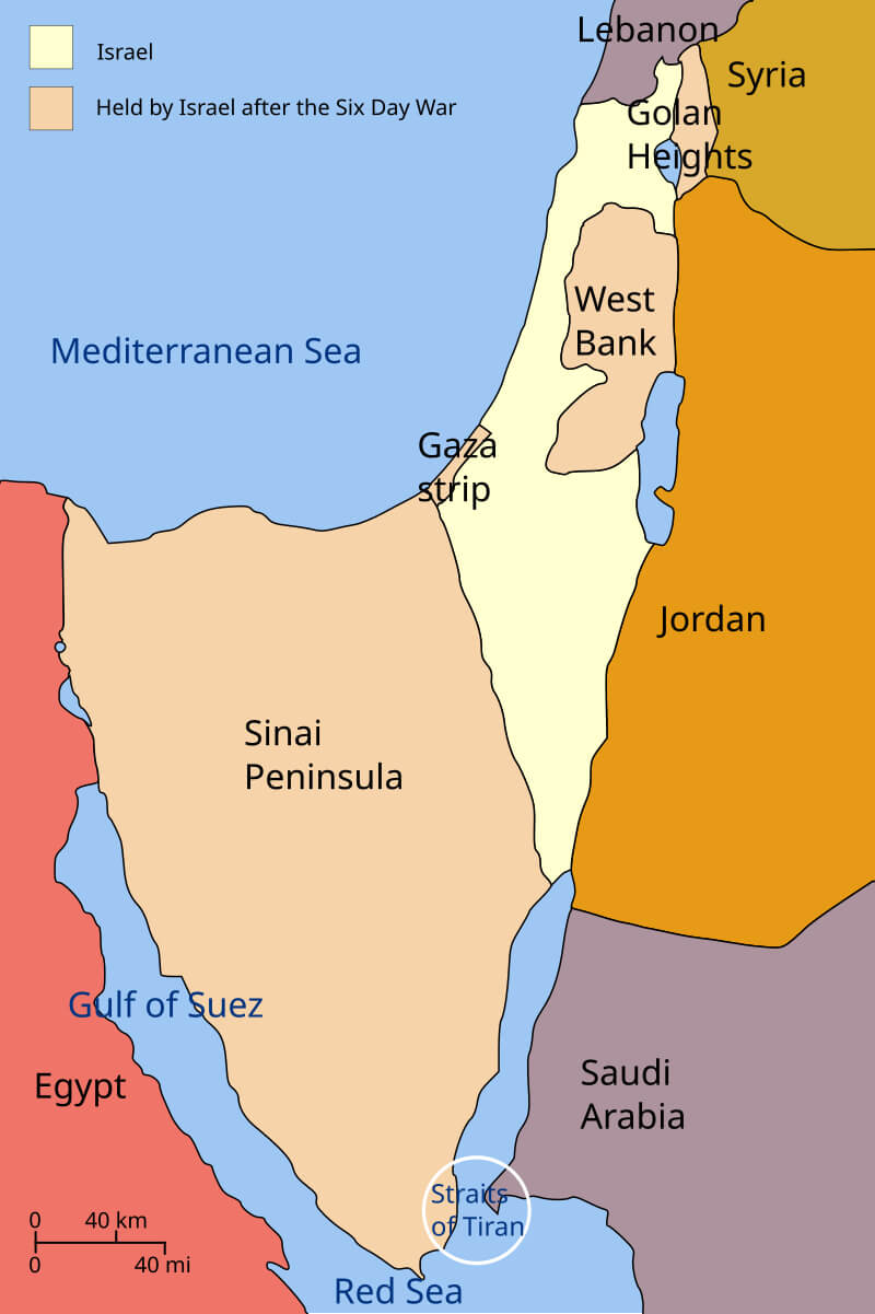
This map illustrates the territorial changes following the 1967 Six Day War, in which Israel captured the Sinai Peninsula, Gaza, the West Bank, and the Golan Heights. The map highlights Israel’s pre-war borders (in yellow) and the territories it held after the conflict (in orange). By 1982, Israel had returned the Sinai Peninsula to Egypt as part of the Egyptian-Israeli peace treaty.
Israel Satellite Map
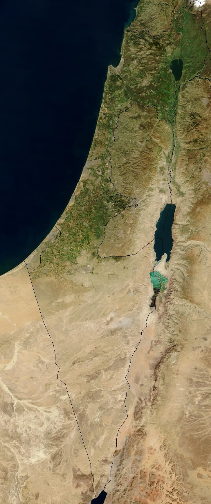
This satellite map of Israel shows the country’s diverse geography, from the Mediterranean coast in the west to the Jordan Valley and Dead Sea in the east. The map highlights Israel’s strategic location between neighboring countries such as Egypt, Jordan, Lebanon, and Syria, as well as its arid southern region extending to the Gulf of Aqaba.
Israel Districts Natural Regions Map
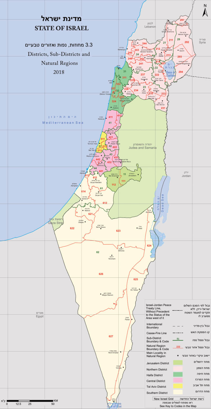
This map of Israel shows the country’s administrative districts and sub-districts, as well as natural regions, as of 2018. Different colors highlight the divisions between districts such as Jerusalem, North, Haifa, Central, Tel Aviv, and South, with significant areas such as the West Bank and Gaza Strip also marked. The map provides a detailed breakdown of each district’s sub-areas and natural regions, reflecting the country’s geopolitical and environmental landscape.
Israel Population Density Map
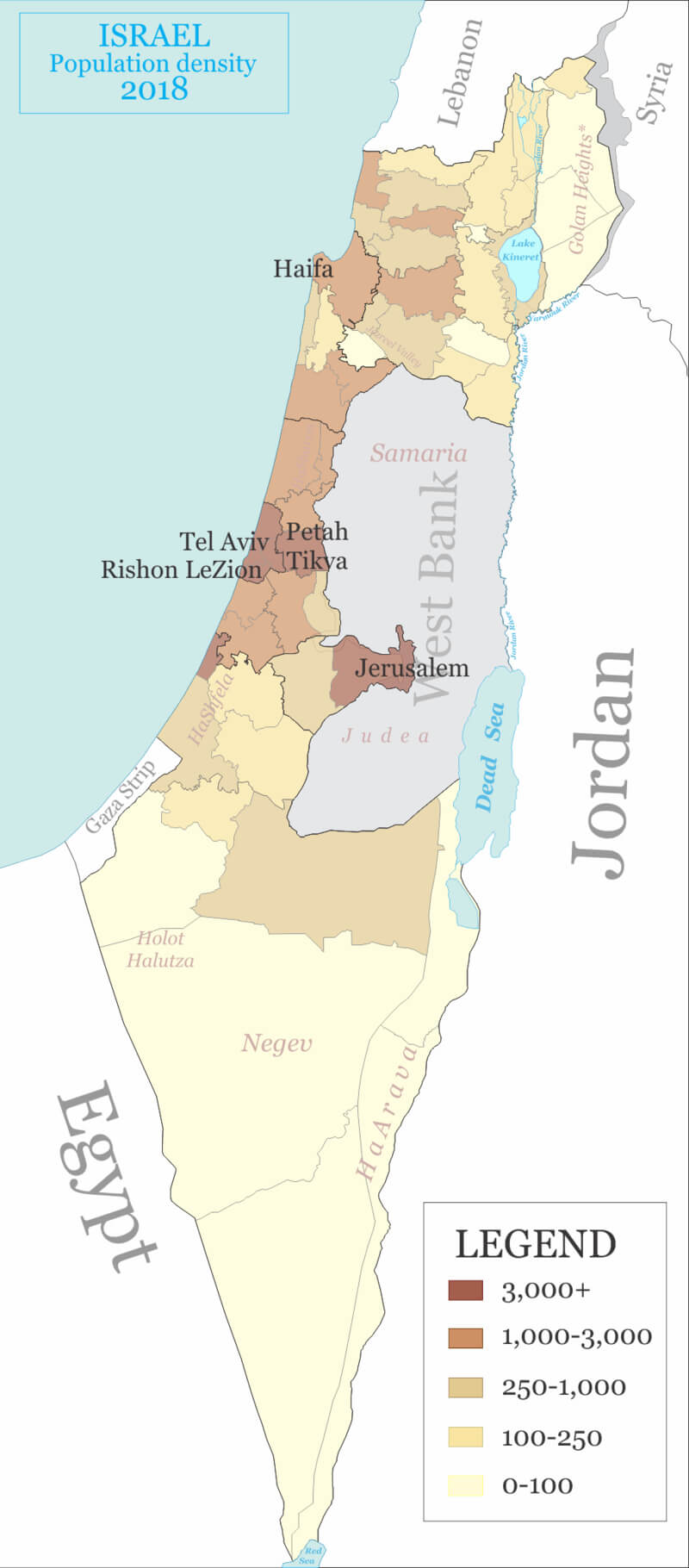
This 2018 map of Israel shows population density in different regions of the country, with darker areas, such as Tel Aviv and Jerusalem, representing high-density zones with more than 3,000 people per square kilometer. In contrast, lighter areas, including the Negev Desert, represent sparsely populated regions with less than 100 people per square kilometer.
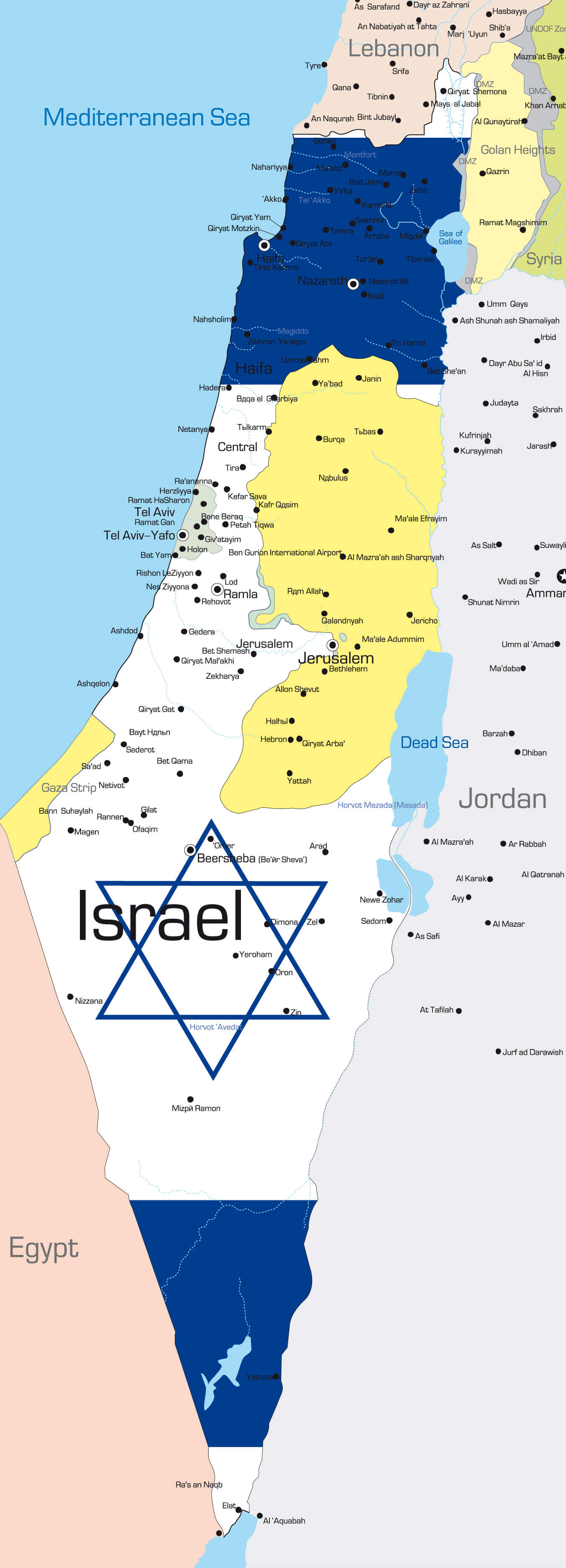
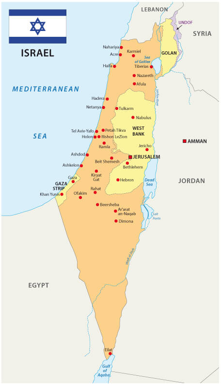
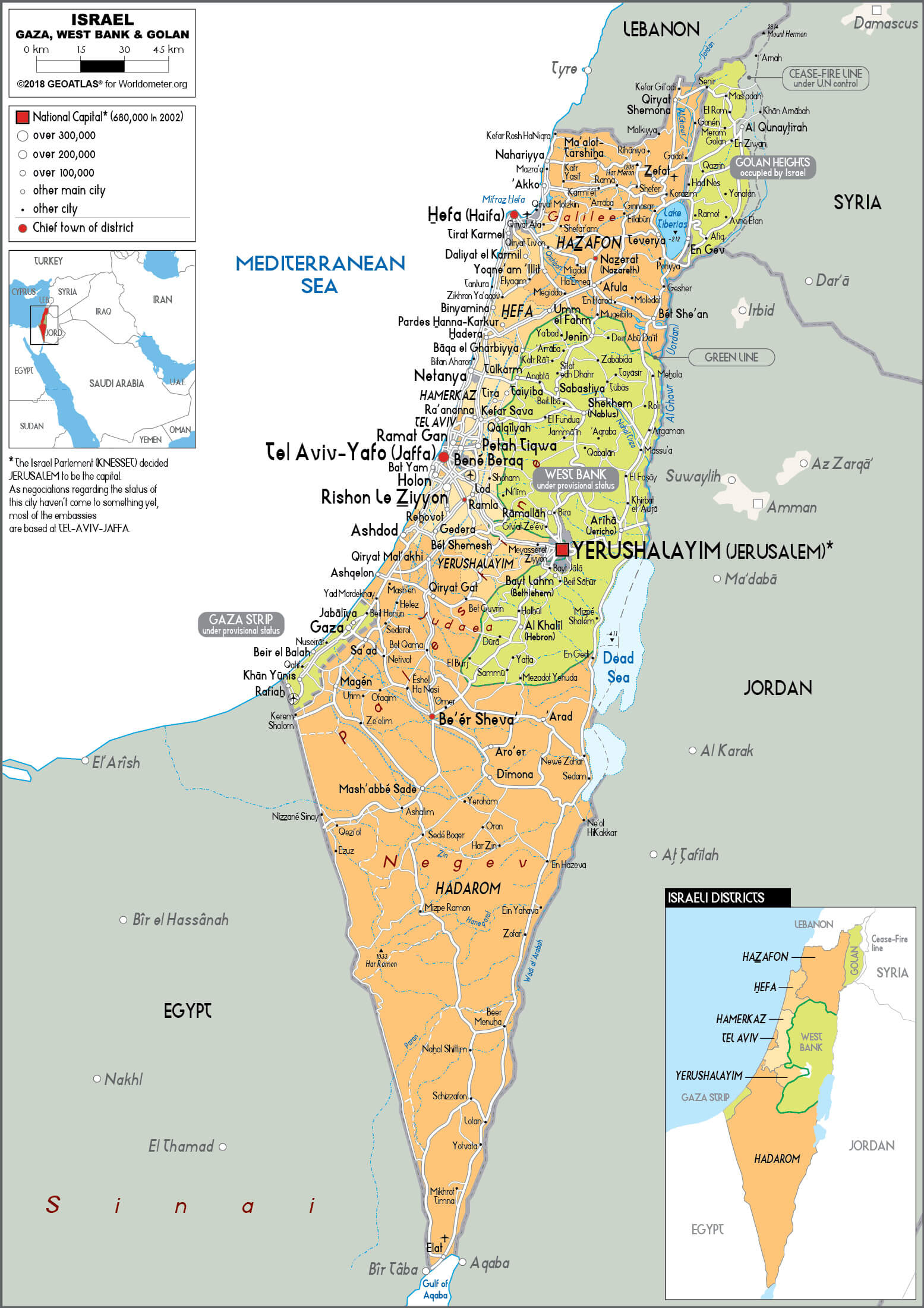
Israel West Bank Gaza Strip Golan Heights Map
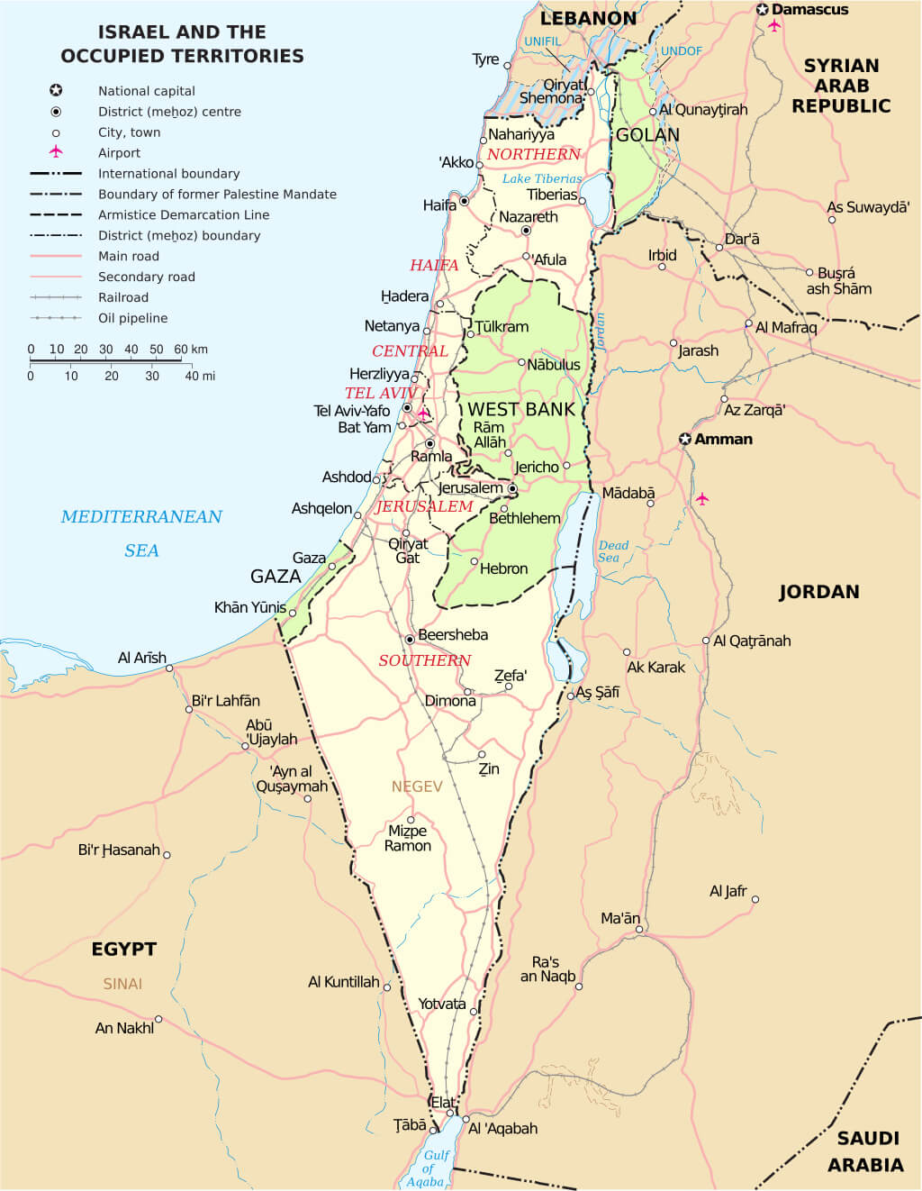
This map shows Israel and the surrounding territories, including the West Bank, Gaza Strip, and Golan Heights, highlighting key features such as international borders, armistice lines, and major cities such as Jerusalem, Tel Aviv, and Haifa. The map also shows regions under various forms of control, including areas with airports, railways, and oil pipelines, as well as important geographic landmarks such as the Negev Desert and Lake Tiberias.
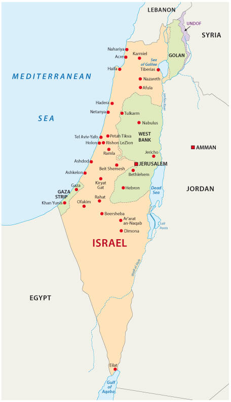
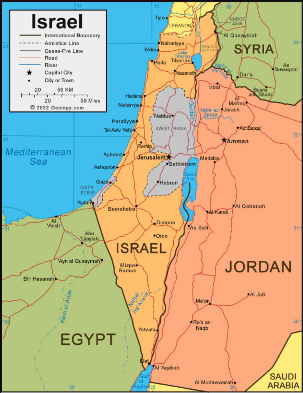
Israel National Border Map
This map of Israel shows national boundaries, major cities including Jerusalem, Tel Aviv, and Haifa, and the West Bank, Gaza Strip, and Golan Heights. The map outlines the districts and includes various towns and cities, highlighting population centers, major highways, and geographic features such as the Dead Sea and the Negev Desert. The armistice line and international borders with neighboring countries such as Jordan, Egypt, Lebanon, and Syria are also clearly marked.
Israel Political Map
This political map of Israel shows its international boundaries with neighboring countries, including Lebanon, Syria, Jordan, and Egypt. Key cities such as Jerusalem, Tel Aviv, Haifa, and Nazareth are marked, along with the West Bank and Gaza Strip territories. The map also highlights major roads, rivers, and the cease-fire lines from past conflicts.
Brief History Map of Israel Expansion
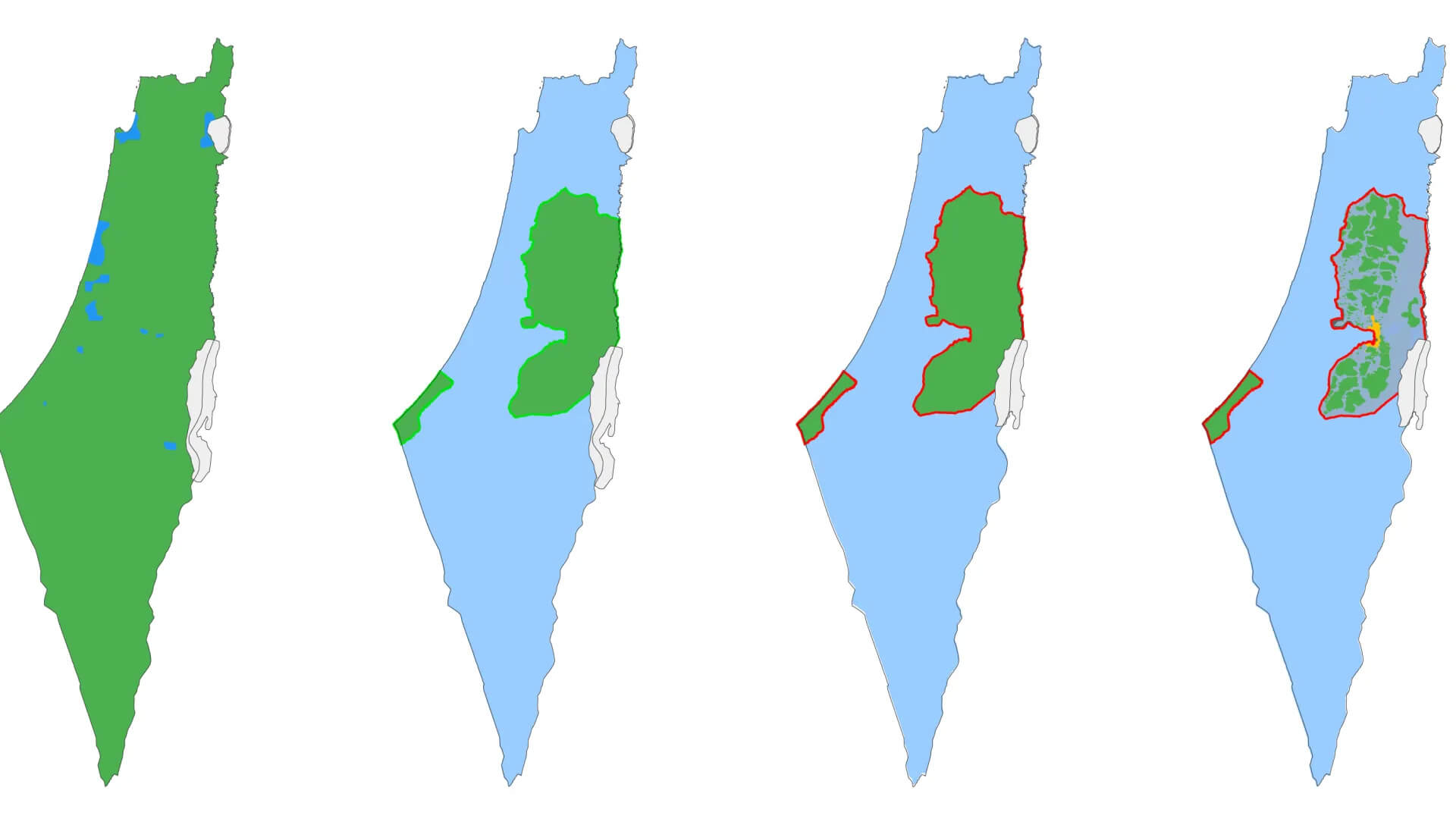
This series of maps illustrates the territorial changes in Israel and Palestine over time, beginning with the UN Partition Plan in 1947, the creation of Israel in 1948, and the subsequent wars and peace agreements that led to the current division of the land, showing areas under Israeli control and Palestinian areas such as the West Bank and Gaza Strip. Each map highlights the shrinking of Palestinian-controlled areas over the decades.
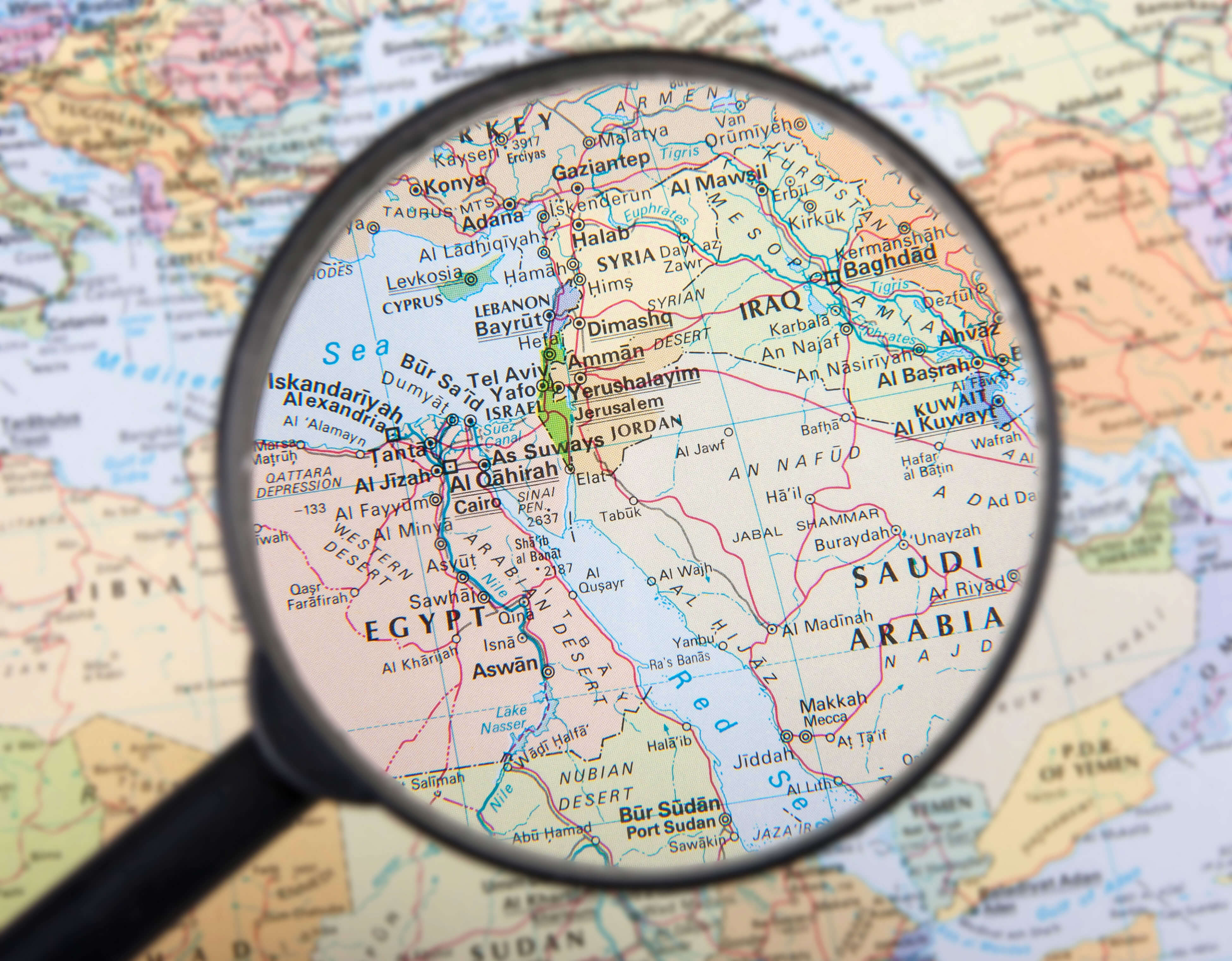
Israel Middle East Countries Map
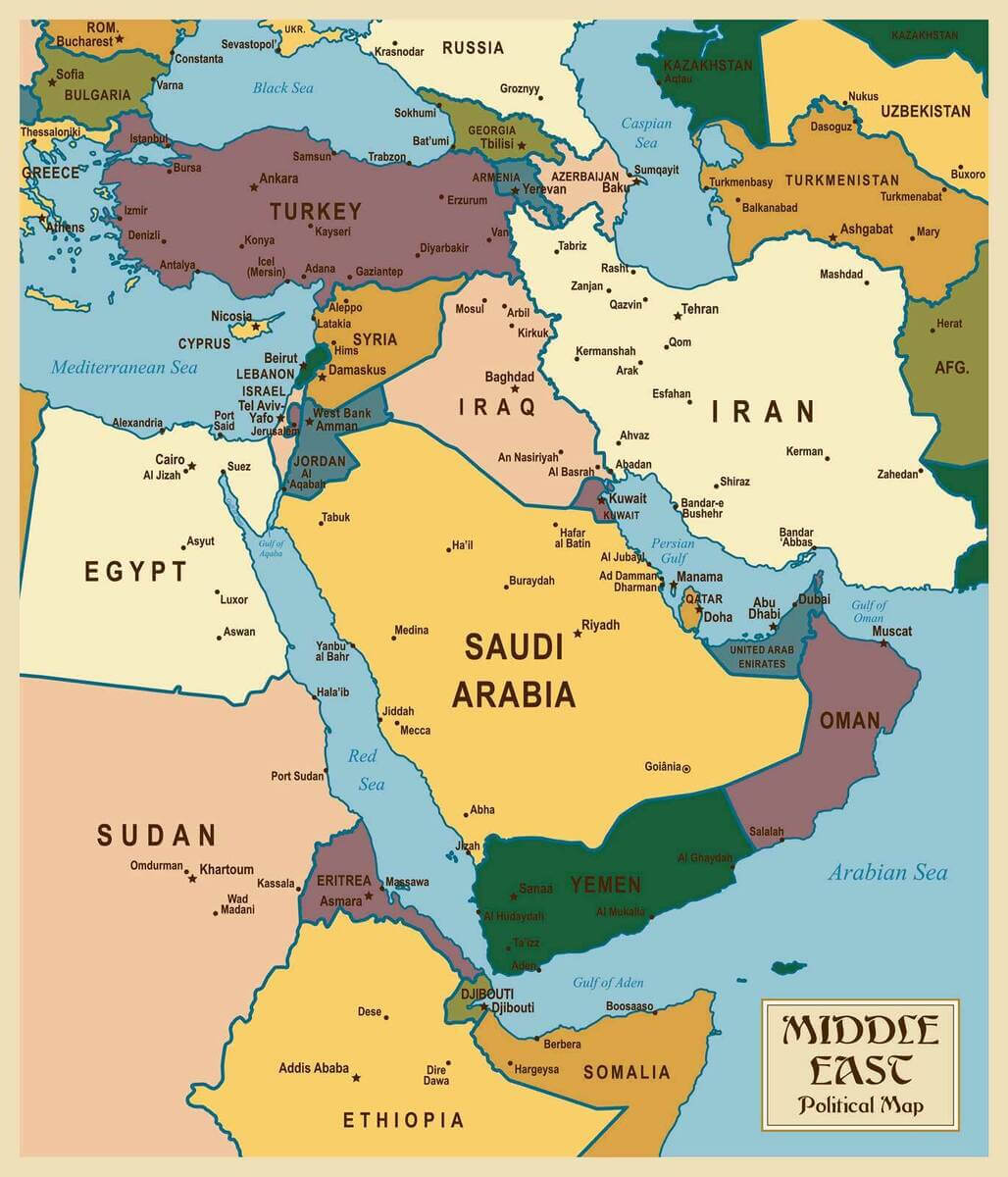
This political map of the Middle East shows Israel’s position in relation to neighboring countries such as Lebanon, Syria, Jordan, and Egypt, as well as major regional powers such as Saudi Arabia, Iran, and Turkey. The map highlights Israel’s central location in a region of significant geopolitical importance, connecting the Mediterranean Sea to the broader Middle East.
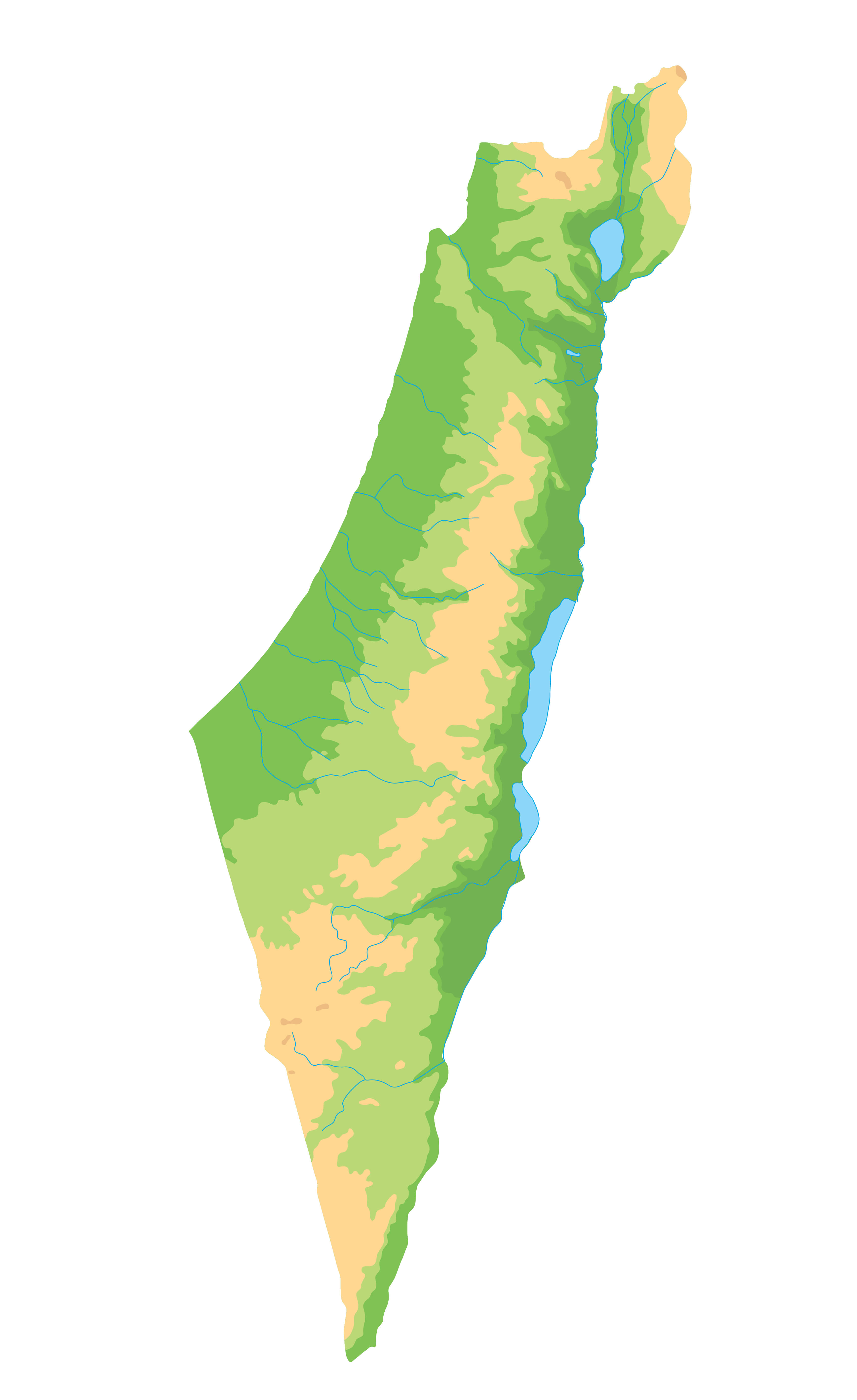
Israel Topography Map
This Israel topography map illustrates the diverse landscape of the country, highlighting the mountainous regions, valleys, and plains. The green areas indicate fertile highlands, while the yellow and red zones represent desert and arid regions, such as the Negev Desert in the south. The map provides a detailed overview of the elevation changes and natural features across Israel.
Where is Israel on the Asia Map?
Show Google map, satellite map, where is the country located.
Get directions by driving, walking, bicycling, public transportation and travel with street view.
Feel free to explore these pages as well:
- Israel Map ↗️
- Map of Israel ↗️
- A Collection of Lebanon Maps ↗️
- Iran Map ↗️
- Tel Aviv’s 10 Best Attractions ↗️
- Europe Map ↗️
- Asia Map ↗️